Potential Double-Digit Rainfall Threatens Florida with Flooding
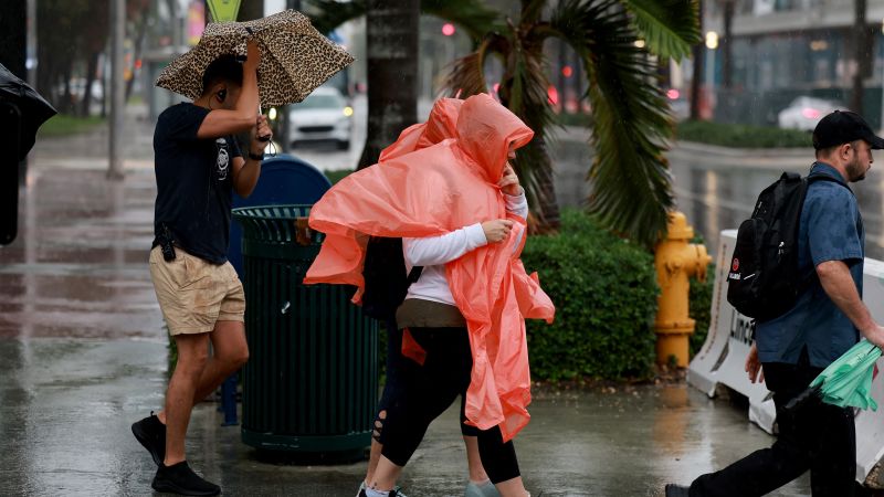
- Over 3 million people in South Florida are at risk of dangerous flash flooding due to ongoing heavy rainfall, causing some roadways to flood and schools to close. Miami-Dade County could experience severe, life-threatening flooding, according to the National Weather Service. A flash flood warning has been issued for the northern and central parts of the county, as well as the Miami and Fort Lauderdale metro areas.
- Areas such as Fort Lauderdale, Miami, and southwest into the Florida Keys could see rainfall totals approach 10 inches in 48 hours. Broward County Public Schools have cancelled classes and closed administrative offices due to safety concerns. Additionally, more than 20,000 homes and businesses lost power in Florida on Wednesday night. There is a moderate risk of excessive rainfall, with rates of 1 to 3 inches per hour possible in the heaviest downpours.
- Parts of Palm Beach County and Broward County already received 3 to 6 inches of rain on Tuesday and are expected to get an additional 8 to 10 inches through Thursday. Total rainfall over three days could exceed a foot in these areas. Fort Lauderdale, which has already had a wet year, could break its record of 102.36 inches set in 1947. Saturated ground and ongoing king tides could slow the water from receding in coastal communities that flood this week.
South Florida in Danger of Severe Flooding
Over 3 million residents of South Florida are at risk of severe flash flooding through early Thursday morning due to continuous heavy rainfall in major metro areas. The rain has already resulted in some roadways flooding and forced school closures.
Areas in Miami-Dade County are warned to prepare for life-threatening flooding, as mentioned by the National Weather Service. The flash flood warning covers the county’s northern and central areas, including the Miami and Fort Lauderdale metro areas, until 6 a.m. ET Thursday.
Difficulties with drainage in coastal areas, due to high tides, and ongoing or expected flash flooding were also highlighted by the weather service in Miami.
In areas where the flash flood warning is live, the 2 to 4 inches of rain already received could be supplemented by another 1 to 4 inches.
Southeast Florida, particularly areas around Fort Lauderdale, Miami, and southwest into the Florida Keys, is expected to bear the brunt with near double-digit rainfall totals over 48 hours.
Due to safety concerns, Broward County Public Schools canceled classes and closed administrative offices on Thursday, as mentioned on their website.
High wind gusts in Lauderdale Lakes, located in Broward County, toppled a tree, destroying two cars, as reported by CNN affiliate WSVN Wednesday.
Poweroutages.us, a power outage tracking website, reported over 20,000 homes and businesses without power in Florida on Wednesday night.
The National Weather Service in Miami has declared a moderate risk of excessive rainfall, a level 3 out of 4, for southeast Florida on Wednesday. The heaviest downpours could give rise to rainfall rates of 1 to 3 inches per hour.
By Wednesday night, Miami received 6.73 inches of rain within the previous 24 hours. Hollywood got 5.62 inches, while Fort Lauderdale had 4.2 inches, according to preliminary reports from the National Weather Service.
This year, Fort Lauderdale has already had an unusually wet year. If this week’s rainfall is as predicted, it’s on track to break the record for the wettest year yet, currently set at 102.36 inches back in 1947.
The Weather Prediction Center suggests that the heavy rainfall through Thursday across southeastern Florida will increase the probability of flash floods in the urban corridor down into the Florida Keys north of Marathon. Meanwhile, the ongoing king tides and saturated ground could slow the water from receding in coastal communities affected by this week’s floods.
—
Read More USA News


Leave a Comment